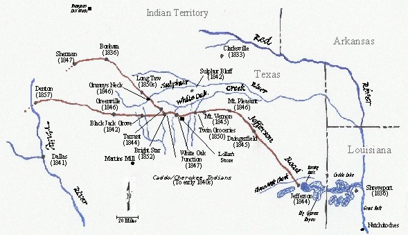
The Old Jefferson Wagon Road
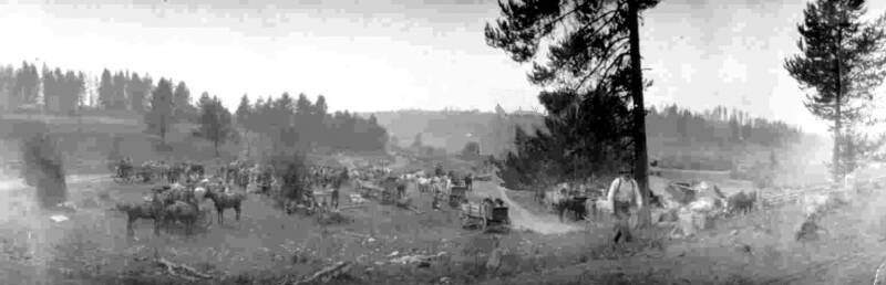
You could hear them coming before you could see them: creaking wagon wheels . . . jangling trace chains . . . horses snorting . . . drivers shouting words of encouragement . . . and an occasional crack of a whip. And sometimes, when it was really dry, you knew where they were before you could see them, for they created a small dust storm. Old timers said at times wagons would be grouped about 50 yards apart and stretched for more than a half mile.
These were wagons bearing supplies from Jefferson, Texas, near the Louisiana border, to the settlements along the way west to the Trinity River near present day Dallas, Texas, a distance of 200 miles. These supplies included sugar, coffee, salt, clothing, shoes and boots, tobacco, whiskey, medicine, and farm implements. Some of these wagons carried supplies for their owner and his neighbors, whereas others hauled for settlement stores. On the return trip to Jefferson these wagons carried wheat, corn, cotton, hides, pork, and lard for the market. Also traveling to market at Jefferson were large ox drawn wagons loaded with cattle, sheep, hogs, turkeys, and mules.
The Jefferson Road was everyone’s road. An occasional stagecoach would use the road as an alternate, and at times a troop of Calvary would follow the road a piece. Cattle were driven over the road to the market in Jefferson. Oxen trains could be seen plodding the road. Horse and mule drawn wagons were there too.
This wagon road had a fortuitous beginning. For it to come about, several seemingly unrelated events had to occur in a short period of time.
For centuries, back to 500 AD, Indians inhabited the area. This was from the Red River to the Gulf Coast, and from Louisiana west, including Northeast Texas. These Indians consisted of several different tribes in three loose confederations: the Hasinai, Natchitoches, and Kadohadacho, the latter being shortened to “Caddo.”
The Caddos lived in round wood and thatch dwellings, and were given to farming pursuits. They grew corn, squash, beans, melons, pumpkin, tobacco, and maize, and traded among themselves and with the white man. Until the 1830s, the Caddo, and other tribes, lived in relative tranquility among themselves and with the Spaniards and French.
In the 1830s things begin to change; Texas became a Republic in 1836, and then a State in 1845. The economic and political climate favored the settling of new areas of the country. The white man was on the move, and so was the Indian. Due to unrest elsewhere, and because they were dislodged from their lands, the more aggressive Cherokee Indians came into Caddo lands, and subdued these somewhat peaceful Indians.
Jefferson Road in the early years
These Cherokees in East Texas became a deterrent to the colonization of the region. The white man was ready to settle the area, but was leery of the Indians.
A few adventurers and scouts from Clarksville, Texas, which is 35 miles northeast of Sulphur Bluff, would occasionally cross the Sulphur River and the Red River into what was later to become Hopkins County. They mostly hunted and looked around, but they didn’t stay long, for they feared being trapped by rising rivers with flooded bottom lands and being left to the mercy of the Indians.
The first white man to settle in what is now Hopkins County was John Bivens, who established himself in 1837 at the site of a former Indian encampment about three miles east of what is now Sulphur Bluff, Texas. Afterward, he was never heard from again, and was feared lost to the Indians.
In 1839, the President of the Republic of Texas, Mirabeau
Lamar, became fed up with Indians marauding the white settlers,
and in effect gave the order to General Kelsey H. Douglass to
wipe them out. The power of the Cherokees, and the Caddos
whom they dominated, was broken. They were for the most part
driven from the area to the north, across the Red River, and onto
the western plains. Thus, the way was open for the white man to come into the area.
A few years later, James Selen Stout, who had been a scout and buffalo hunter with Sam Houston’s Army in its fight with the Mexicans (1836), and who knew the country well, led a group of eighteen people, who were originally from Indiana, from Clarksville, Texas, to settle in 1842 at a bluff, later was named Sulphur Bluff. After that settlers from Georgia, Alabama, Tennessee, Arkansas, and elsewhere begin to arrive in the area.
At the time of the settlement of Sulphur Bluff, which became the first trading point in the area, goods had to be hauled by oxen either from Shreveport on the Red River or from Little Rock on the Arkansas.
At the end of the 17th century a Great Raft began to form on the Red River in Louisiana near Natchitoches. It consisted of logs and debris from eroding river banks. By the 19th century it ran from Nachitoches upstream past Shreveport for a total of about 160 miles. The clogged-up river created lake rafts and bayous. It also made navigation on the Red River in Louisiana almost impossible.
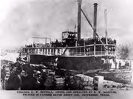
In 1833 Captain Henry M. Shreve, who commanded the U.S. Army Corps of Engineers, set about clearing out the raft using snag steamboats. By 1836 he had successfully cleared the river from Natchitoches to Shreveport, a stretch of 71 miles. This permitted boats to come up the Mississippi River from New Orleans into the Red River and on to Shreveport.
In early 1844, a steam boat named Ilama was able to make it from Shreveport, Louisiana, to the present site of Jefferson, Texas, by following the channel of Cypress Bayou. Jefferson was then linked to the Red River . . . and New Orleans. It thus became the trading point for all of Northeast Texas. This development led to Jefferson becoming the commercial gateway to the West.
Almost immediately upon learning that boats could make it to Jefferson, a road was cut through any timber or brush in its path from the town, with a 60-foot right of way, heading west. There were, of course, no bridges, culverts, and ramps, as with today’s roads. And, as a practical matter, many early roads followed buffalo and Indian trails. And where possible, these roads followed the divides, the high ground. The road from Jefferson went north to Daingerfield, then northwest to Mount Pleasant, then west toward the interior of Texas.
When the Road was first established, there were mostly just places on it where teamsters like to camp. To cater to them and to settlers in the vicinity, a store would crop up here and there. Later, a settlement would develop around the store and camp.
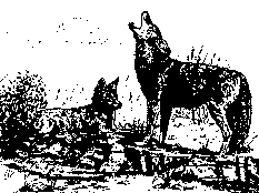
Teamsters plying the Jefferson Road were a tough and diverse lot. They had to contend with boredom, dust, heat, cold, renegade Indians, marauding wolves, flooded creeks, mud, broken wagons, balky mules, strayed-off teams, and bandits.
They also had their good times. There was fresh meat from deer and turkey to eat. A bath in a creek or river was most welcome after a day’s drive in the heat and dust. And as a day wore on, they could always look forward to the conversation and banter with other teamsters when they camped for the night. They had their preferences as to the best places to camp, what kind of teams they liked. They told stories and created their own lore about the Road.
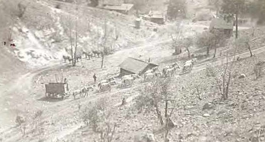
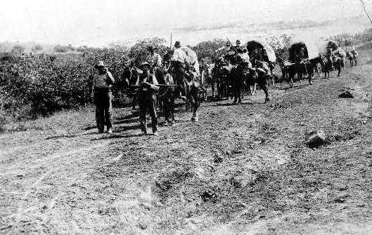
Mule trains making their way
One story related by an old muleskinner was about a stop at Bright Star. Before the wagon train got settled for the night, a stranger approached the camp site. The operator of a nearby store, also a stranger to those with the wagon train, stepped out and shot the approaching man to death. Although the teamsters knew neither man in the shooting, they were required to make depositions that covered their knowledge of what happened. Since they wanted to make an early start toward their homes in Bonham the next day, they were allowed to sign statements and depart.
There was always talk around camp as to what was the best team for the Road. Oxen were favored by many because of their strength, temperament, and cost. They also didn’t stray at night and could graze off the land, which was a plus. They were also less preferred by Indians. Horses and mules had to be fed grain on the road, but they were faster than oxen. Oxen could pull a wagon about two miles per hour, whereas horses and mules could make about two and a half miles per hour. There was endless talk on this subject.
One campsite frequented the most by the drivers was Three-Mile- Creek just outside of Jefferson. They would camp on the creek and then the following morning go into Jefferson and conduct their business. By dark they would be back at the creek, and be ready to head west the next morning.
Another favorite place to camp for these men was Twin Groceries. It was an excellent camping ground, and people going east would camp early in order to let their teams graze on the prairie. Those going west would travel late in order to do likewise. Some drivers would leave grain at this camp for their horses and mules for their return trip.
J. T. "Bud” Arthur, whose family was one of the first to settle at Twin
Groceries, was interviewed by G. G. Orren in 1937. Speaking about
wagons and teams on the Jefferson Road, Arthur said, ". . . from one to
three spans of mules were used and from one to three yoke of oxen,
mostly two of each. It took about eight or ten days with oxen and six to
eight days with mules to make a trip from this famous camping place to
Jefferson." He was talking about a distance of 73 miles.
White Oak Junction was one of the settlements on the Road. It was a good place to stop, for it had the most famous store, Lollar’s, on the Road.
Black Jack Grove with its stand of oak trees, that was used by Texas Rangers as a camp when Texas was a Republic, was another favored spot to spend the night by the wagoners.
The settlement of Long Taw on the Road to Bonham got its name from the freight haulers. Long Taw meant it was a long haul to water at the Sulphur River on the way to Jefferson.
Bob McGill was a regular teamster on this Road before the Civil War. He drove freight wagons for J. M. Smoot & Co. of Denton, hauling from Jefferson mostly, but from any point where supplies could be obtained. On one occasion they were unable to get salt from normal supply points and McGill had to go to Giles Thompson's Salt Works in Indian Territory. He took with him a load of Jugware for trade, mostly to the Indians. The Territory was wild then, made up mostly of Indians. and there was real danger. People preferred to travel in groups, but McGill had to make this trip alone.
A teamster camp
Into the journey, he saw signs there might be unrest around him and was worried about nightfall. He planned to move into his camp after dark, and do a fire, but, as night approached, he heard sounds made by a group of whites with wagons and was glad to join them for the night.
Later McGill moved to Greenwood, seven miles south of Twin Groceries where he continued to haul freight from Jefferson. He made trips mostly for his neighbors, the store of Winders, Pitts and Company at Pine Forest to the west, and the Green H. Crowder store up by Twin Groceries. Eventually he hauled for himself, as he and his sons established a store at Greenwood.
During the Civil War, Jefferson became very important to the Confederacy as supplier of meat, hides, food staples, iron, munitions, and leather goods.
In the years following the Civil War, Jefferson reached
its heyday with people coming from the devastated southern
states seeking a new life. In 1872, there were exports in the
thousands of dry hides, green hides, tons of wool, pelts,
and bushels of seed. Several thousand cattle and sheep,
and over a hundred thousand feet of lumber were also
transported. For the same period, there were 226 arrivals
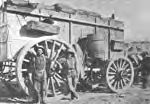
of steamboats with a carrying capacity averaging 425 A freight wagon. Sometimes two
tons each. wagons were hooked in tandem
Jefferson was second only to Galveston as a shipping and pulled by eight horses/mules
port. When cotton became the more dominant crop in
Northeast Texas before the advent of railroads, steamboats were ideal for transporting bulky 500 pound bales of cotton.
Because of the commercial importance of Jefferson as a marketplace, a network of feeder roads to the Jefferson Road were established. Some roads went directly to Jefferson.
Some store owners made periodic trips to Jefferson. Bob Wallace and John Burrage operated a general merchandising store at Martins Mill, 56 miles south of Black Jack Grove, in the late 1870s. Their main shipping points for supplies for their store was Shreveport and Jefferson. It took two weeks, and sometimes longer, to make this trip to Jefferson in an ox wagon.
Mr. Wallace made these trips alone many times and camped any place along the rough road he happened to be at sundown. Most of the time he would have several slabs of salt bacon and he had to keep a big fire burning all night to keep the wolves from attacking him. They could smell the meat and a hungry wolf is sometimes vicious. Wallace insisted he was not afraid.
Steamboat at dock in Jefferson
There were not many bridges at this time and if it rained much, one had to wait until the water receded to cross the creeks or rivers. On one trip to Jefferson, Mr. Wallace's ox wagon bogged down in the middle of the crossing and he had to unload the supplies and carry them to the other bank so the team could pull the wagon through. Pioneer men like Bob Wallace were strong as horses and no job was too hard for them to tackle.
Individuals also made trips to Jefferson for supplies. Francis Turner, who lived at Pine Forest, which was 6½ miles south of White Oak Junction, had an account with Ward and Gist and Murphy and Co., Dallas and Austin Streets, Jefferson, Texas. His statement of May 25, 1871 for February 9 to May 17, 1871 was for: "56 lbs rope 12.31; 2 sks salt 4.50; 3 kegs nails 16.50; 2 bbl flour 17.00; 44 gallons molasses at .60 26.40; 165 lbs coffee at .18 29.70; discount on currency, 19.30. Paid Jefferson May 27, 1871."
Jim Richey, who also lived at Pine Forest, hauled cotton to Jefferson. It was said he was supremely honest. On one occasion he took a load to Jefferson. He sold the cotton and completed his business, and drove out to the camp site on Three-Mile-Creek. There he checked his cash and found $40 too much. He re-checked his figures carefully and still came out with $40 ahead. There seemed to be no doubt the cotton factor had paid him too much for his cotton. Jim went back into Jefferson to the factor's office and told his story, and offered return of the $40. The factor pointed to a sign on the wall that read: “NO MISTAKES CORRECTED AFTER LEAVING THIS ROOM.”
After 1875, Jefferson as a marketplace begin to decline. In 1873 the Corp of Engineers were determined to clear the Red River Raft all the way north to its end. In a few years, using Shreve’s snag boats, cranes, saws, and dynamite, they were successful. For Jefferson, however, the result was unfavorable, for it lowered the water level in Big Cypress Bayou so that steamboats could no longer reach Jefferson. This coupled with the coming of the railroads lessen the importance of Jefferson as a trading center, and subsequently the Jefferson Road as a transportation artery.
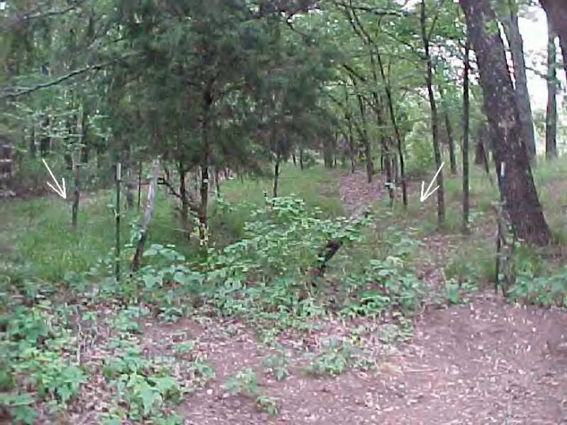
Today there are vestiges of the Old Jefferson Wagon Road. Its roadbed is still visible in places. When it was in use they let trees grow at its edges so to prevent erosion. For the most part its path is now on private property. Aerial photos and satellite images show the roadbed here and there. The road is not always straight, and seems to wander in places. This is because when a teamster came to a muddy hole where his wagon may have bogged down, he simply went around it . . . as did those who came after him.
One can still find traces and fragments of the old stores' foundations and chimneys at Twin Groceries (Old Saltillo) and White Oak Junction (near Weaver, Texas). There are also houses still standing today that were built with lumber and square nails hauled from Jefferson.
——
The writer spent his boyhood at Saltillo, a mile and a half north of Twin Groceries, which was later called Old Saltillo. He now resides in Toledo, Ohio where he is Professor Emeritus and Superannuate in
the College of Engineering at the University of Toledo.
Sources:
HOPKINS COUNTY." The Handbook of Texas Online. <http://www.tsha.utexas.edu/handbook/online/articles/view/HH/hch18.html> [Accessed Mon Jul 5 7:35:39 US/Central 2004 ].
"JEFFERSON, TX." The Handbook of Texas Online. <http://www.tsha.utexas.edu/handbook/online/articles/view/JJ/hgj2.html> [Accessed Mon Jul 5 7:39:24 US/Central 2004 ].
"A Brief History of Jefferson and Marion County."
http://www.jefferson-texas.com/history.htm [Accessed Mon Jul 5 7:42:24 US/Central 2004 ].
“Historical Information of Hopkins County.”http://http.rootsweb.com/pub/usgenweb/tx/hopkins/history/mcdonald1.txt [Accessed Mon Jul 5 7:42:24 US/Central 2004 ].
Information about satellite images, trails, and vegetation. James Fletcher
“History of Saltillo.”http://ftp.rootsweb.com/pub/usgenweb/tx/hopkins/history/saltillo.txt [Accessed Mon Jul 5 7:42:24 US/Central 2004 ].
“Red River Raft.”http://www.ok-history.mus.ok.us/enc/rdrivrft.htm [Accessed Mon Jul 5 7:42:24 US/Central 2004 ].
Post, Gerald (1988). Alive and Good to Know. Dallas: Curtis Media Corporation.
Van Zandt County Texas Biographies 1848-1991 Vol. II
G. G. Orren, The History of Hopkins County (M.A. thesis, East Texas State Teachers College, 1938).